
Overview:
| Type: | Hill Fort |
| Location: | Situated in Aundhewadi village between Nasik and Ahmadnagar in Maharashtra. |
| District: | Nashik |
A North-south range of Sahyadri, which turns from Igatpuri towards eastern Thal Ghat, is known as ‘Kalsubai Range’. Alang, Madan, Kulang and Kalsubai is one part of Kalsubai Range and the other part is at the east i.e. Aundh, Patta, Bitangad, Aad and mountain of Mhasoba.
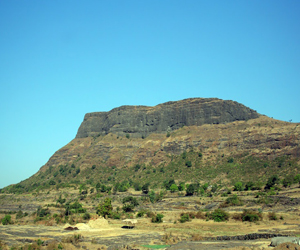
 Aundha Fort, or Avandha Killa, is in Aundhewadi village between Nasik and Ahmadnagar in Maharashtra. This Fort lies in the Sahyadri mountain range at a height of about 4,300 ft (1.31 km) above sea level. Aundha fort is close to Patta fort. The residents of Patta Killa are known as Pattekar, meaning “residents of Fort Patta”.
The fort of Aundha is like a pinnacle, since top of the fort is very small. Main use of this place was to keep a watch on the surrounding region. We can see 4-5 cisterns on the fort. Water is available in one cave. There is an entrance carved here from the huge rock
History:
History of this fort is similar to the adjoining Patta fort. Till 1688 the fort was under Maratha rule. On 11 January 1688, Moghul captured this fort. Later, in 1761 Peshwas captured this fort.
Patta was used at the border of the Swarajya. When Shivaji Maharaj was coming after winning Jalnapur (Jalna of today), the mughal army trapped him from three sides. It was because of the mastery of Bahirji Naik who was the head of the detective department that shivaji maharaj was able to reach Patta safely. Height of Patta fort from Mean sea Level 1392 Meters (4566 feet (1.39 km))
Finally, in 1818 this British won this fort.
Places to Visit on Fort:
 This fort is very difficult to climb due to the broken stone cut steps at many places. Except for rock-cut cisterns and steps which lead to the highest point, there are very few structures left on the Fort.
The fort of Aundh is like a pinnacle, since top of the fort is very small. Main use of this place was to keep a check on the surrounding region. We can see 4-5 cisterns on the fort. Water is available in one cave. There is an entrance carved here from the huge rock.
Most popular places to visit are:-
· A cave, Mandir & water pond at top of fort.
· Awesome view of Kadwa reservoir.
· C-shape of mountains surrounding fort.
· A watch post, on the top of the fort.
We can see Patta fort, Bitangad, Alang, Madan, Kulang, Kalsubai and the surrounding area from this fort. Half an hour is enough to see the fort.
How to reach:
Go to Igatpuri via Mumbai. Take bus for Bhagur from Igatpuri bus station at 7 a.m. and get down at Kadva Colony Naka. This journey takes about one and half-hour. Going further from Kadva Colony we reach at Kadva dam. From this way we reach Ninavi village after 45 minutes. Through this village we can go towards the fort by two ways.
1) The first way is through a ridge in the cliff ahead. However, this way is quite tiring.
2) The other way goes along the Hanuman Temple. This way takes 45 minutes to reach the Plateau. After some rock-climbing, we can reach the top.
The Nearest airport is Gandhinagar Airport. International airport is at Mumbai with 140 km and nearest railway station is Igatpuri.
Nearby Places
Bhakti Dham, Nashik
Shree Kapaleshwar Mahadev, Nashik
Shree Laxmi Narayan Temple, Tapovan
Shree Ved Temple, Nashik
Sita Gumpha (Cave), Nashik
Related Video (Aundha / Avandha Fort):
Best time to visit:
Best time to visit is from July to February.


